
Make a donation
Gear up for your next adventure:
As an Amazon Associate, this site earns from qualifying purchases at no extra cost to you.
Figueirinha topographic map
Click on the map to display elevation.
Make a donation
Gear up for your next adventure:
As an Amazon Associate, this site earns from qualifying purchases at no extra cost to you.
About this map
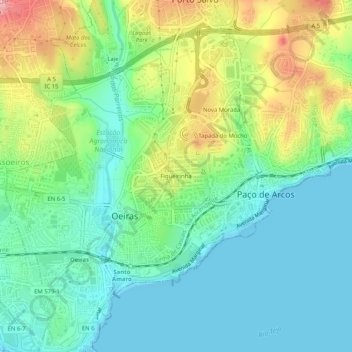
Name: Figueirinha topographic map, elevation, terrain.
Average elevation: 40 m
Minimum elevation: 0 m
Maximum elevation: 124 m
Make a donation
Gear up for your next adventure:
As an Amazon Associate, this site earns from qualifying purchases at no extra cost to you.
Other topographic maps
Click on a map to view its topography, its elevation and its terrain.
Barcarena
A povoação de Barcarena estende-se ao longo das margens leste e oeste da ribeira com o mesmo nome, situada na parte mais profunda do vale, numa cota de 58 metros relativa ao nível do mar. Está ladeada por duas encostas simétricas, são duas colinas com cerca de 130 metros de altitude, situadas quer no…
Average elevation: 108 m
Make a donation
Gear up for your next adventure:
As an Amazon Associate, this site earns from qualifying purchases at no extra cost to you.
Make a donation
Gear up for your next adventure:
As an Amazon Associate, this site earns from qualifying purchases at no extra cost to you.