Geolocate

Fleurier topographic map

Click on the map to display elevation.

About this map

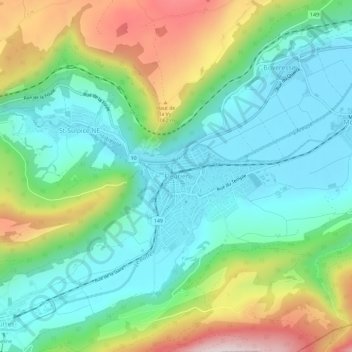
Name: Fleurier topographic map, elevation, terrain.

Location: Fleurier, Val-de-Travers, Neuchâtel, 2114, Suisse (46.88428 6.56004 46.92428 6.60004)

Average elevation: 893 m

Minimum elevation: 729 m

Maximum elevation: 1,259 m

Gear up for your next adventure:

🧣Merino Neck Gaiter - Protects against wind, sun, and cold at high altitudes
🥾Hiking Gaiters - Protect legs and shoes from mud, snow, and debris
🧰Survival Kit - Essential gear for emergencies in the wilderness
🥾Mountain Hiking Shoes - Shoes with superior grip for mountainous terrain
🔭Outdoor Binoculars - Lightweight binoculars for birdwatching and hiking

As an Amazon Associate, this site earns from qualifying purchases at no extra cost to you.