Geolocate

Iguala topographic map

Click on the map to display elevation.

About this map

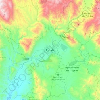
Name: Iguala topographic map, elevation, terrain.

Location: Iguala, Iguala de la Independencia, Guerrero, 40080, Mexico (18.18664 -99.69769 18.50664 -99.37769)

Average elevation: 1,110 m

Minimum elevation: 577 m

Maximum elevation: 2,405 m

Gear up for your next adventure:

🥾Hiking Shoes - Durable and comfortable shoes for trail hiking
Lightweight Backpacking Tent - Compact tent for efficient hiking trips
🥾Trail Hiking Shoes - Durable shoes designed for rugged trails
🔋Solar Power Bank - Keep your GPS and devices charged during long outdoor trips
🥾Waterproof Trail Shoes - Shoes designed to handle wet terrain

As an Amazon Associate, this site earns from qualifying purchases at no extra cost to you.