Geolocate

Hammerbach topographic map

Click on the map to display elevation.

About this map

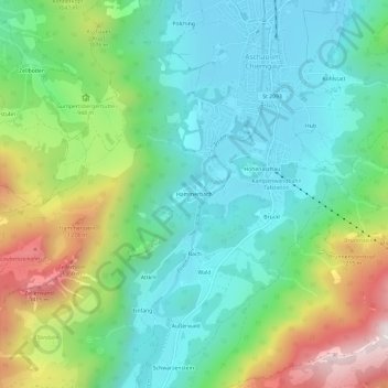
Name: Hammerbach topographic map, elevation, terrain.

Location: Hammerbach, Aschau im Chiemgau, Landkreis Rosenheim, Bayern, 83229, Deutschland (47.74282 12.29295 47.78282 12.33295)

Average elevation: 871 m

Minimum elevation: 598 m

Maximum elevation: 1,500 m

Other topographic maps

Click on a map to view its topography, its elevation and its terrain.

Gear up for your next adventure:

🔭Compact Binoculars - Lightweight optics for scouting trails and wildlife
🛰️Satellite Messenger - Emergency communication for areas with no cell service
🌡️Emergency Mylar Blankets - Compact thermal protection for unexpected nights outdoors
🧢Sun Hat - Wide-brim hat for sun protection
🛁Quick-Dry Microfiber Towel - Space-saving towel that dries rapidly on the move

As an Amazon Associate, this site earns from qualifying purchases at no extra cost to you.