Geolocate

Schlag topographic map

Click on the map to display elevation.

About this map

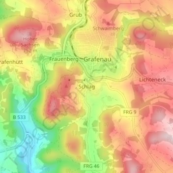
Name: Schlag topographic map, elevation, terrain.

Location: Schlag, Grafenau, Landkreis Freyung-Grafenau, Bayern, 94481, Deutschland (48.82988 13.37320 48.86988 13.41320)

Average elevation: 615 m

Minimum elevation: 438 m

Maximum elevation: 762 m

Other topographic maps

Click on a map to view its topography, its elevation and its terrain.

Gear up for your next adventure:

🛌Insulated Sleeping Pad - Critical thermal barrier between you and the cold ground
🧥Packable Rain Jacket - Breathable waterproof layer for unpredictable weather
🥾Mountain Trail Shoes - High-traction shoes for mountain trails
🎒Backpack Rain Cover - External shield to keep your entire pack dry
🥘Camping Cookware Set - Compact nesting pots and pans for trail cooking

As an Amazon Associate, this site earns from qualifying purchases at no extra cost to you.