
Make a donation
Gear up for your next adventure:
As an Amazon Associate, this site earns from qualifying purchases at no extra cost to you.
Kawauchi topographic map
Click on the map to display elevation.
Make a donation
Gear up for your next adventure:
As an Amazon Associate, this site earns from qualifying purchases at no extra cost to you.
Kawauchi
Kawauchi is located in the Abukuma Plateau of central Fukushima with a mean altitude of between 400 and 500 meters. North of Kawauchi, there is at 37°22′53″N 140°48′16″E / 37.38139°N 140.80444°E / 37.38139; 140.80444 (Kawauchi Substation) a substation of Kita–Iwaki powerline, a 500 kV-line already designed for future 1100 kV operation.
Make a donation
Gear up for your next adventure:
As an Amazon Associate, this site earns from qualifying purchases at no extra cost to you.
About this map
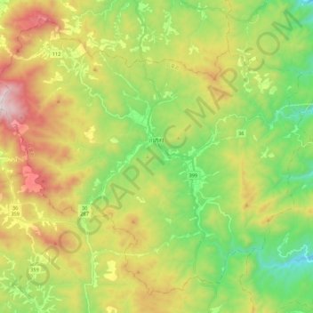
Name: Kawauchi topographic map, elevation, terrain.
Location: Kawauchi, Futaba County, Fukushima Prefecture, Japan (37.25149 140.69899 37.40463 140.91684)
Average elevation: 574 m
Minimum elevation: 166 m
Maximum elevation: 1,188 m
Make a donation
Gear up for your next adventure:
As an Amazon Associate, this site earns from qualifying purchases at no extra cost to you.
Other topographic maps
Click on a map to view its topography, its elevation and its terrain.