
Buch-Sankt Magdalena topographic map
Interactive map
Click on the map to display elevation.
About this map
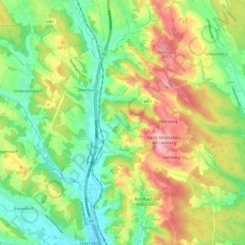
Name: Buch-Sankt Magdalena topographic map, elevation, terrain.
Average elevation: 358 m
Minimum elevation: 290 m
Maximum elevation: 456 m
Other topographic maps
Click on a map to view its topography, its elevation and its terrain.
Sankt Magdalena am Lemberg
Österreich > Steiermark > Bezirk Hartberg-Fürstenfeld > Buch-Sankt Magdalena > Sankt Magdalena am Lemberg
Sankt Magdalena am Lemberg, Buch-Sankt Magdalena, Bezirk Hartberg-Fürstenfeld, Steiermark, 8247, Österreich
Average elevation: 381 m