Geolocate

Galalan topographic map

Click on the map to display elevation.

About this map

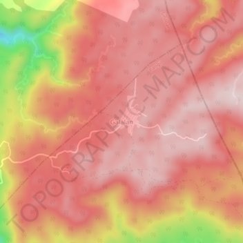
Name: Galalan topographic map, elevation, terrain.

Location: Galalan, Pangil, Laguna, Calabarzon, 4019, Philippines (14.42353 121.48522 14.46353 121.52522)

Average elevation: 417 m

Minimum elevation: 139 m

Maximum elevation: 514 m

Gear up for your next adventure:

🧰Multitool Knife - Compact and versatile tool for outdoor use
💡Portable Camping Lamp - Rechargeable lamp for campsite lighting
🛶Canoe Life Vest - Safety vest for water sports
Lightweight Backpacking Tent - Compact tent for efficient hiking trips
🥾Waterproof Trail Shoes - Shoes designed to handle wet terrain

As an Amazon Associate, this site earns from qualifying purchases at no extra cost to you.