Geolocate

Lodi topographic map

Click on the map to display elevation.

About this map

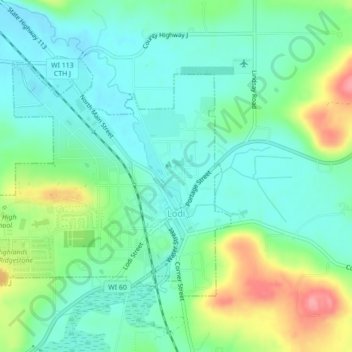
Name: Lodi topographic map, elevation, terrain.

Location: Lodi, Columbia County, Wisconsin, United States (43.30643 -89.56318 43.32798 -89.51969)

Average elevation: 269 m

Minimum elevation: 240 m

Maximum elevation: 337 m

Other topographic maps

Click on a map to view its topography, its elevation and its terrain.

Fall River

United States > Wisconsin > Columbia County

Average elevation: 266 m

Dekorra

United States > Wisconsin > Columbia County

Average elevation: 259 m

Englewood

United States > Wisconsin > Columbia County

Average elevation: 276 m

Gear up for your next adventure:

🚲Heavy Duty Bike Lock - Secure your bike at the trailhead or during stops
🥾Durable Hiking Shoes - Long-lasting shoes for frequent hiking
🧢Sun Protection Cap - Breathable cap to protect from sun exposure
🥽Outdoor Goggles - Protective eyewear for outdoor activities
Camping Groundsheet - Protect your tent from moisture and dirt

As an Amazon Associate, this site earns from qualifying purchases at no extra cost to you.