
Thank you for supporting this site ❤️
Make a donation
Make a donation
Gear up for your next adventure:
As an Amazon Associate, this site earns from qualifying purchases at no extra cost to you.
Mittagskogel topographic map
Click on the map to display elevation.
Thank you for supporting this site ❤️
Make a donation
Make a donation
Gear up for your next adventure:
As an Amazon Associate, this site earns from qualifying purchases at no extra cost to you.
Mittagskogel
Der Mittagskogel, slowenisch Kepa (kärntner-slowenisch Jepa), ist mit einer Höhe von 2145 m ü. A. einer der höchsten Berge der westlichen Karawanken. Er liegt an der österreichisch-slowenischen Grenze.
Thank you for supporting this site ❤️
Make a donation
Make a donation
Gear up for your next adventure:
As an Amazon Associate, this site earns from qualifying purchases at no extra cost to you.
About this map
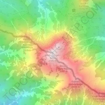
Name: Mittagskogel topographic map, elevation, terrain.
Average elevation: 1,574 m
Minimum elevation: 1,119 m
Maximum elevation: 2,125 m
Thank you for supporting this site ❤️
Make a donation
Make a donation
Gear up for your next adventure:
As an Amazon Associate, this site earns from qualifying purchases at no extra cost to you.