
Make a donation
Gear up for your next adventure:
As an Amazon Associate, this site earns from qualifying purchases at no extra cost to you.
Kontich-Kazerne topographic map
Click on the map to display elevation.
Make a donation
Gear up for your next adventure:
As an Amazon Associate, this site earns from qualifying purchases at no extra cost to you.
Kontich-Kazerne
De Bautersemsebeek ontspringt in het bronnengebied Bautersem en het Broekbos. Ze verlaat Kontich-Kazerne nabij Alfacam naar Lint. Daarnaast stroomt ook de Babbelkroonbeek, die in Waarloos ontspringt, door de wijk en verlaat deze ter hoogte van het Kapellekesbos eveneens richting Lint.
Make a donation
Gear up for your next adventure:
As an Amazon Associate, this site earns from qualifying purchases at no extra cost to you.
About this map
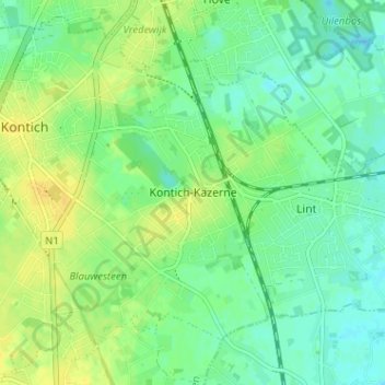
Name: Kontich-Kazerne topographic map, elevation, terrain.
Location: Kontich-Kazerne, Kontich, Antwerpen, Vlaanderen, 2540, België (51.10853 4.45343 51.14853 4.49343)
Average elevation: 14 m
Minimum elevation: 5 m
Maximum elevation: 25 m
Make a donation
Gear up for your next adventure:
As an Amazon Associate, this site earns from qualifying purchases at no extra cost to you.
Other topographic maps
Click on a map to view its topography, its elevation and its terrain.