Geolocate

Tinyarumi topographic map

Click on the map to display elevation.

About this map

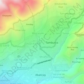
Name: Tinyarumi topographic map, elevation, terrain.

Location: Tinyarumi, Tamburco, Provincia de Abancay, Apurímac, Perú (-13.64172 -72.89816 -13.60172 -72.85816)

Average elevation: 2,678 m

Minimum elevation: 2,240 m

Maximum elevation: 3,613 m

Gear up for your next adventure:

🧢Outdoor Visor - Breathable visor for sunny hikes
🧢Sun Protection Cap - Breathable cap to protect from sun exposure
🧦Outdoor Socks - Durable socks designed for hiking and outdoor sports
🧼Biodegradable Camp Soap - Environmentally friendly cleaning for gear and body
🌡️Emergency Mylar Blankets - Compact thermal protection for unexpected nights outdoors

As an Amazon Associate, this site earns from qualifying purchases at no extra cost to you.