Geolocate

Newberg topographic map

Click on the map to display elevation.

Newberg

According to the United States Census Bureau, the city has a total area of 5.81 square miles (15.05 km2), all land. It averages 176 feet (54 m) in elevation.

Wikipedia (CC-BY-SA 3.0)

About this map

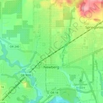
Name: Newberg topographic map, elevation, terrain.

Location: Newberg, Yamhill County, Oregon, United States (45.28088 -122.98978 45.33011 -122.92562)

Average elevation: 61 m

Minimum elevation: 20 m

Maximum elevation: 164 m

Other topographic maps

Click on a map to view its topography, its elevation and its terrain.

Amity Hills

United States > Oregon > Yamhill County > Amity

Average elevation: 108 m

Gear up for your next adventure:

🥾All-Terrain Hiking Boots - Versatile boots for varied hiking conditions
💧Hydration Pack - Hands-free hydration system for long hikes
🧭Orienteering Kit - Tools for map reading and navigation in the wild
🧣Evaporative Cooling Towel - Beat the heat during intense summer climbs
🔋Solar Power Bank - Keep your GPS and devices charged during long outdoor trips

As an Amazon Associate, this site earns from qualifying purchases at no extra cost to you.