Geolocate

Star Hill topographic map

Click on the map to display elevation.

About this map

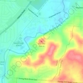
Name: Star Hill topographic map, elevation, terrain.

Location: Star Hill, Heath, Licking County, Ohio, 43056, United States (40.02745 -82.42278 40.02755 -82.42268)

Average elevation: 279 m

Minimum elevation: 246 m

Maximum elevation: 334 m

Gear up for your next adventure:

🚲Heavy Duty Bike Lock - Secure your bike at the trailhead or during stops
🧼Travel Hand Sanitizer - Keep hands clean when water is scarce
🧰Survival Kit - Essential gear for emergencies in the wilderness
🧢Outdoor Visor - Breathable visor for sunny hikes
🛶Canoe Life Vest - Safety vest for water sports

As an Amazon Associate, this site earns from qualifying purchases at no extra cost to you.