Make a donation
Gear up for your next adventure:
As an Amazon Associate, this site earns from qualifying purchases at no extra cost to you.
Gegu topographic map
Click on the map to display elevation.
Make a donation
Gear up for your next adventure:
As an Amazon Associate, this site earns from qualifying purchases at no extra cost to you.
About this map
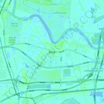
Name: Gegu topographic map, elevation, terrain.
Location: Gegu, Tianjin, China (38.94768 117.46185 39.02768 117.54185)
Average elevation: 2 m
Minimum elevation: -5 m
Maximum elevation: 7 m
Make a donation
Gear up for your next adventure:
As an Amazon Associate, this site earns from qualifying purchases at no extra cost to you.
Other topographic maps
Click on a map to view its topography, its elevation and its terrain.
Make a donation
Gear up for your next adventure:
As an Amazon Associate, this site earns from qualifying purchases at no extra cost to you.
Make a donation
Gear up for your next adventure:
As an Amazon Associate, this site earns from qualifying purchases at no extra cost to you.
Make a donation
Gear up for your next adventure:
As an Amazon Associate, this site earns from qualifying purchases at no extra cost to you.
Nankai District
Nankai District is located in the south-west corner of the urban Tianjin, bordered by Hongqiao District to the north, Hebei and Heping Districts to the north-east, Hexi District to the east and Xiqing District to the south-west. It occupies an area of 40.64 square kilometres (15.69 sq mi). The natural…
Average elevation: 6 m
Make a donation
Gear up for your next adventure:
As an Amazon Associate, this site earns from qualifying purchases at no extra cost to you.
