Geolocate

Lourdes topographic map

Click on the map to display elevation.

About this map

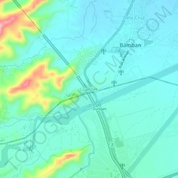
Name: Lourdes topographic map, elevation, terrain.

Location: Lourdes, Bamban, Tarlac, Central Luzon, 2317, Philippines (15.24338 120.53759 15.28338 120.57759)

Average elevation: 98 m

Minimum elevation: 65 m

Maximum elevation: 232 m

Other topographic maps

Click on a map to view its topography, its elevation and its terrain.

Marimla River

Philippines > Tarlac > Bamban > Lourdes

Average elevation: 79 m

Gear up for your next adventure:

Camping Coffee Maker - Brew fresh coffee anywhere on the topographic map
🥾Mountain Trail Shoes - High-traction shoes for mountain trails
🔥Emergency Fire Starter - Reliable ignition source for all weather conditions
🛰️Satellite Messenger - Emergency communication for areas with no cell service
Lightweight Camping Tent - Portable shelter optimized for Canadian backcountry camping

As an Amazon Associate, this site earns from qualifying purchases at no extra cost to you.