Geolocate

Marchissy topographic map

Click on the map to display elevation.

About this map

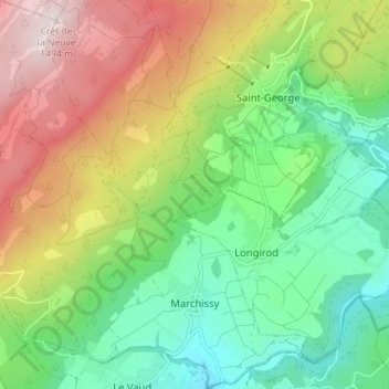
Name: Marchissy topographic map, elevation, terrain.

Location: Marchissy, District de Nyon, Vaud, 1261, Switzerland (46.47725 6.19685 46.52594 6.26743)

Average elevation: 1,018 m

Minimum elevation: 721 m

Maximum elevation: 1,490 m

Other topographic maps

Click on a map to view its topography, its elevation and its terrain.

Gear up for your next adventure:

🧥Waterproof Hiking Jacket - Protect yourself from rain and wind while hiking
🥾Trekking Poles - Adjustable trekking poles to reduce knee stress and improve stability
🧢Hiking Hat - Sun-protective and breathable hats for long treks
🧢Outdoor Cap - Protective cap for sun and rain during hikes
🥾Waterproof Hiking Shoes - Durable shoes for wet and rugged trails

As an Amazon Associate, this site earns from qualifying purchases at no extra cost to you.