
Thank you for supporting this site ❤️
Make a donation
Make a donation
Gear up for your next adventure:
As an Amazon Associate, this site earns from qualifying purchases at no extra cost to you.
Lienz topographic map
Click on the map to display elevation.
Thank you for supporting this site ❤️
Make a donation
Make a donation
Gear up for your next adventure:
As an Amazon Associate, this site earns from qualifying purchases at no extra cost to you.
About this map
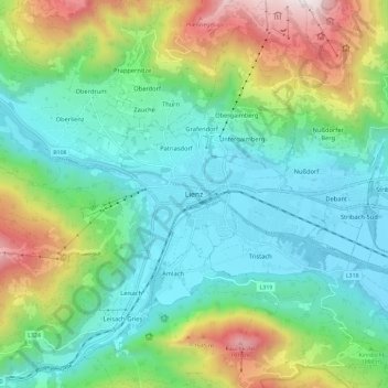
Name: Lienz topographic map, elevation, terrain.
Location: Lienz, Stadt Lienz, Bezirk Lienz, Tirol, 9900, Österreich (46.78987 12.72813 46.86987 12.80813)
Average elevation: 1,050 m
Minimum elevation: 650 m
Maximum elevation: 2,056 m
Thank you for supporting this site ❤️
Make a donation
Make a donation
Gear up for your next adventure:
As an Amazon Associate, this site earns from qualifying purchases at no extra cost to you.