Geolocate

Kakdwip topographic map

Click on the map to display elevation.

Kakdwip

Kakdwip is located at 21°52′45″N 88°11′29″E / 21.8791446°N 88.1912992°E / 21.8791446; 88.1912992. It has an average elevation of 4 metres (13 ft).

Wikipedia (CC-BY-SA 3.0)

About this map

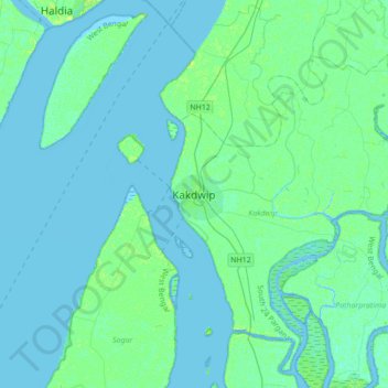
Name: Kakdwip topographic map, elevation, terrain.

Location: Kakdwip, South 24 Parganas, West Bengal, 743347, India (21.71603 88.02528 22.03603 88.34528)

Average elevation: 2 m

Minimum elevation: -3 m

Maximum elevation: 12 m

Gear up for your next adventure:

🔭Outdoor Binoculars - Lightweight binoculars for birdwatching and hiking
🧰Survival Kit - Essential gear for emergencies in the wilderness
🍽️Titanium Camping Spork - Ultralight and indestructible eating utensil
🧥Fleece Jacket - Warm and lightweight jacket for layering
🧥Insulated Jacket - Keep warm in cold outdoor conditions

As an Amazon Associate, this site earns from qualifying purchases at no extra cost to you.