Geolocate

Oeiras topographic map

Click on the map to display elevation.

About this map

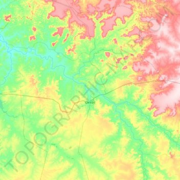
Name: Oeiras topographic map, elevation, terrain.

Location: Oeiras, Região Geográfica Imediata de Oeiras, Região Geográfica Intermediária de Picos, Piauí, Northeast Region, 64500-000, Brazil (-7.31800 -42.62618 -6.61700 -41.87568)

Average elevation: 261 m

Minimum elevation: 120 m

Maximum elevation: 515 m

Other topographic maps

Click on a map to view its topography, its elevation and its terrain.

Serra Brava

Brazil > Piauí > São João da Canabrava

Average elevation: 536 m

Regalia

Brazil > Piauí > Aroazes

Average elevation: 226 m

Tanque Velho

Brazil > Piauí > São Braz do Piauí

Average elevation: 492 m

Balisa

Brazil > Piauí

Average elevation: 536 m

Serra da Capivara

Brazil > Piauí > Alto Longá

Average elevation: 241 m

Salobinho

Brazil > Piauí > Cajazeiras do Piauí

Average elevation: 164 m

Ilha

Brazil > Piauí > São Miguel do Tapuio

Average elevation: 183 m

Cariré

Brazil > Piauí > Buriti dos Montes

Average elevation: 394 m

Serra da Capivara

Brazil > Piauí > Alto Longá

Average elevation: 241 m

Jatobá Fechado

Brazil > Piauí > Buriti dos Montes

Average elevation: 504 m

Gear up for your next adventure:

🥾Trail Hiking Boots - Supportive boots for rough trails
🥾Waterproof Trail Shoes - Shoes designed to handle wet terrain
🥾Waterproof Hiking Boots - Essential footwear for rugged terrain and wet Canadian trails
🏃Hydration Running Vest - Carry water and maps close to your body for speed
🦟Insect Repellent - Keep mosquitoes and black flies away in wooded areas

As an Amazon Associate, this site earns from qualifying purchases at no extra cost to you.