
Saint-Étienne-des-Sorts topographic map
Interactive map
Click on the map to display elevation.
About this map
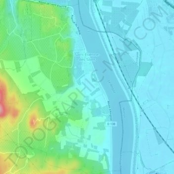
Name: Saint-Étienne-des-Sorts topographic map, elevation, terrain.
Average elevation: 59 m
Minimum elevation: 31 m
Maximum elevation: 175 m
Other topographic maps
Click on a map to view its topography, its elevation and its terrain.
Le Marchand
Francia > Occitania > Gard > Saint-Félix-de-Pallières
Le Marchand, Saint-Félix-de-Pallières, Le Vigan, Gard, Occitania, Francia metropolitana, 30140, Francia
Average elevation: 314 m