Geolocate

Romeral topographic map

Click on the map to display elevation.

About this map

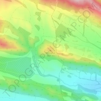
Name: Romeral topographic map, elevation, terrain.

Location: Romeral, Aibar, Comarca de Sangüesa, Navarra, 31400, España (42.59766 -1.32668 42.59776 -1.32658)

Average elevation: 536 m

Minimum elevation: 435 m

Maximum elevation: 697 m

Gear up for your next adventure:

🚲Heavy Duty Bike Lock - Secure your bike at the trailhead or during stops
🔭Compact Monocular - One-handed bird watching and trail spotting
🧢Sun Hat - Wide-brim hat for sun protection
🧥Fleece Jacket - Warm and lightweight jacket for layering
🥾Approach Boots - Comfortable boots for hiking and climbing approaches

As an Amazon Associate, this site earns from qualifying purchases at no extra cost to you.