
Make a donation
Gear up for your next adventure:
As an Amazon Associate, this site earns from qualifying purchases at no extra cost to you.
Heksenberg topographic map
Click on the map to display elevation.
Make a donation
Gear up for your next adventure:
As an Amazon Associate, this site earns from qualifying purchases at no extra cost to you.
About this map
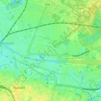
Name: Heksenberg topographic map, elevation, terrain.
Average elevation: 35 m
Minimum elevation: 27 m
Maximum elevation: 46 m
Make a donation
Gear up for your next adventure:
As an Amazon Associate, this site earns from qualifying purchases at no extra cost to you.
Other topographic maps
Click on a map to view its topography, its elevation and its terrain.
Sint-Lambrechts-Herk
België > Limburg > Hasselt > Hasselt
In het noorden stroomt nog de Waanbeek, die bij Stevoort in de Herk uitmondt. In het oosten van het gebied ligt een heuvelrug welke tot 66 meter hoogte reikt, op de Nok van Sint-Lambrechts-Herk, deze nok scheidt het bekken van Mombeek en Herk van het Demerbekken. Nok omdat de Boom klei hier ondiep voorkomt in…
Average elevation: 41 m