
City of Fremantle topographic map
Interactive map
Click on the map to display elevation.
About this map
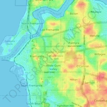
Name: City of Fremantle topographic map, elevation, terrain.
Location: City of Fremantle, Western Australia, Australia (-32.08213 115.72395 -32.02117 115.80327)
Average elevation: 22 m
Minimum elevation: -9 m
Maximum elevation: 68 m
Other topographic maps
Click on a map to view its topography, its elevation and its terrain.
Cathedral Gorge
Australia > Western Australia > Newman
Cathedral Gorge, Newman, Shire Of East Pilbara, Western Australia, Australia
Average elevation: 618 m
Ningaloo Australian Marine Park
Ningaloo Australian Marine Park, Western Australia, Australia
Average elevation: 17 m
Jurien Bay
Jurien Bay, Shire Of Dandaragan, Western Australia, 6516, Australia
Average elevation: 45 m
Cottesloe Beach
Australia > Western Australia > Town of Cottesloe
Cottesloe Beach, Cottesloe, Town of Cottesloe, Western Australia, Australia
Average elevation: 10 m
Mullewa
Mullewa, City Of Greater Geraldton, Western Australia, 6630, Australia
Average elevation: 277 m
Kununurra
Kununurra, Shire Of Wyndham-East Kimberley, Western Australia, 6743, Australia
Average elevation: 74 m
Kings Park
Kings Park, Western Australia, Australia
Average elevation: 31 m
Singleton
Singleton, City Of Rockingham, Western Australia, 6175, Australia
Average elevation: 7 m
Blythewood
Blythewood, Shire Of Murray, Western Australia, Australia
Average elevation: 14 m
Waterford
Australia > Western Australia > City of South Perth
Waterford, City of South Perth, Western Australia, 6152, Australia
Average elevation: 8 m
Derby
Derby, Shire Of Derby-West Kimberley, Western Australia, Australia
Average elevation: 8 m
Gwelup
Gwelup, City Of Stirling, Western Australia, Australia
Average elevation: 18 m
Nilgen
Nilgen, Shire Of Gingin, Western Australia, Australia
Average elevation: 61 m
Claremont
Australia > Western Australia > Town of Claremont
Claremont, Town of Claremont, Western Australia, 6010, Australia
Average elevation: 19 m
Perth
Australia > Western Australia > City of Perth
Perth, City of Perth, Western Australia, 6000, Australia
Average elevation: 26 m
Balingup
Balingup, Shire Of Donnybrook-Balingup, Western Australia, Australia
Average elevation: 227 m
Warwick
Warwick, City Of Joondalup, Western Australia, Australia
Average elevation: 32 m
Cockburn Range
Cockburn Range, Western Australia, Australia
Average elevation: 188 m
Brunswick River
Brunswick River, Shire Of Harvey, Western Australia, 6233, Australia
Average elevation: 120 m
Shire Of Mundaring
Shire Of Mundaring, Western Australia, Australia
Average elevation: 222 m
Point Walter
Point Walter, Bicton, City Of Melville, Western Australia, 6156, Australia
Average elevation: 12 m
Mumballup
Mumballup, Shire Of Donnybrook-Balingup, Western Australia, Australia
Average elevation: 216 m
Mcalinden
Mcalinden, Shire Of Boyup Brook, Western Australia, Australia
Average elevation: 251 m
Jarrahdale
Jarrahdale, Shire Of Serpentine-Jarrahdale, Western Australia, 6124, Australia
Average elevation: 213 m
Boulder
Boulder, City Of Kalgoorlie-Boulder, Western Australia, 6432, Australia
Average elevation: 349 m
City of Perth
City of Perth, Western Australia, Australia
Average elevation: 18 m
City Of Bunbury
City Of Bunbury, Western Australia, Australia
Average elevation: 12 m
Town of Victoria Park
Town of Victoria Park, Western Australia, Australia
Average elevation: 15 m
Lake Wells
Lake Wells, Shire Of Laverton, Western Australia, Australia
Average elevation: 463 m
Coral Bay
Coral Bay, Shire Of Carnarvon, Western Australia, Australia
Average elevation: 5 m
Karijini National Park
Karijini National Park, Karijini, Shire Of Ashburton, Western Australia, Australia
Average elevation: 688 m
Cape Naturaliste
Cape Naturaliste, City Of Busselton, Western Australia, Australia
Average elevation: 11 m
Manypeaks
Manypeaks, City Of Albany, Western Australia, 6328, Australia
Average elevation: 87 m
Yanmah
Yanmah, Shire Of Manjimup, Western Australia, Australia
Average elevation: 251 m
City Of Karratha
City Of Karratha, Western Australia, Australia
Average elevation: 136 m
Yanchep
Yanchep, City Of Wanneroo, Western Australia, 6035, Australia
Average elevation: 25 m
Bickley
Bickley, City Of Kalamunda, Western Australia, Australia
Average elevation: 281 m
Shire Of Wandering
Shire Of Wandering, Western Australia, Australia
Average elevation: 309 m
Margaret River
Margaret River, Shire Of Augusta Margaret River, Western Australia, 6285, Australia
Average elevation: 89 m
Armadale
Armadale, City Of Armadale, Western Australia, Australia
Average elevation: 98 m
Carnarvon
Carnarvon, Shire Of Carnarvon, Western Australia, Australia
Average elevation: 4 m
Shire Of Plantagenet
Shire Of Plantagenet, Western Australia, Australia
Average elevation: 159 m
Dunsborough
Dunsborough, City Of Busselton, Western Australia, 6281, Australia
Average elevation: 32 m
City Of Busselton
City Of Busselton, Western Australia, Australia
Average elevation: 44 m
Sir James Mitchell National Park
Sir James Mitchell National Park, Diamond Tree, Shire Of Manjimup, Western Australia, Australia
Average elevation: 180 m
Kookynie
Kookynie, Shire Of Menzies, Western Australia, Australia
Average elevation: 398 m
Prince Regent River
Prince Regent River, Shire Of Wyndham-East Kimberley, Western Australia, Australia
Average elevation: 285 m
City Of Albany
City Of Albany, Western Australia, Australia
Average elevation: 97 m
Wiluna
Wiluna, Shire Of Wiluna, Western Australia, Australia
Average elevation: 553 m
Macleay Island
Macleay Island, Shire Of Derby-West Kimberley, Western Australia, Australia
Average elevation: 4 m