
Make a donation
Gear up for your next adventure:
As an Amazon Associate, this site earns from qualifying purchases at no extra cost to you.
Dohna topographic map
Click on the map to display elevation.
Make a donation
Gear up for your next adventure:
As an Amazon Associate, this site earns from qualifying purchases at no extra cost to you.
Dohna
Daher waren Burg und Siedlung an dieser Stelle für die Kontrolle der Handelswege (Salzstraßen) im Müglitztal (Böhmischer Weg) und über die Höhen (Kulmer Steig beziehungsweise Alte Dresden Teplitzer Poststraße) von besonderer Bedeutung. Der Annalista Saxo erwähnte zwischen 1148 und 1152 Dohna zum Jahr 1040: das Heer von König Heinrich III. sammelte sich bei Dohna und unternahm über den Kulmer Steig einen siebentägigen Einfall nach Böhmen. Im Jahr 1076 belehnte Heinrich IV. den Herzog Vratislav II. von Böhmen mit den Gauen Budissin und Nisan, zu dem auch Dohna gehörte. Dieser gab Nisan mit Dohna als Mitgift seiner Tochter in die Ehe mit Wiprecht von Groitzsch, allerdings unter der Lehnshoheit von Vratislav II.
Make a donation
Gear up for your next adventure:
As an Amazon Associate, this site earns from qualifying purchases at no extra cost to you.
About this map
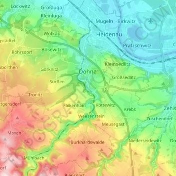
Name: Dohna topographic map, elevation, terrain.
Average elevation: 211 m
Minimum elevation: 110 m
Maximum elevation: 407 m
Make a donation
Gear up for your next adventure:
As an Amazon Associate, this site earns from qualifying purchases at no extra cost to you.
Other topographic maps
Click on a map to view its topography, its elevation and its terrain.
Bayer
Deutschland > Sachsen > Sächsische Schweiz-Osterzgebirge > Dippoldiswalde
Average elevation: 359 m
Grundwasser
Deutschland > Sachsen > Sächsische Schweiz-Osterzgebirge > Hohnstein
Average elevation: 372 m