
Make a donation
Gear up for your next adventure:
As an Amazon Associate, this site earns from qualifying purchases at no extra cost to you.
Halls Crossroads topographic map
Click on the map to display elevation.
Make a donation
Gear up for your next adventure:
As an Amazon Associate, this site earns from qualifying purchases at no extra cost to you.
Halls Crossroads
It is located at 36°04′49″N 83°56′33″W / 36.08028°N 83.94250°W / 36.08028; -83.94250. It has an elevation of 1,040 feet.
Make a donation
Gear up for your next adventure:
As an Amazon Associate, this site earns from qualifying purchases at no extra cost to you.
About this map
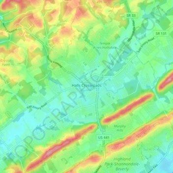
Name: Halls Crossroads topographic map, elevation, terrain.
Average elevation: 346 m
Minimum elevation: 295 m
Maximum elevation: 447 m
Make a donation
Gear up for your next adventure:
As an Amazon Associate, this site earns from qualifying purchases at no extra cost to you.
Other topographic maps
Click on a map to view its topography, its elevation and its terrain.
Whites Village
United States > Tennessee > Knox County > Knoxville > Whites Village
Average elevation: 288 m