Geolocate

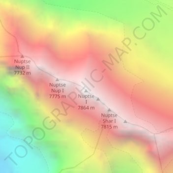
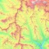
Nuptse I topographic map

Click on the map to display elevation.

Nuptse I

Nuptse or Nubtse is a mountain in the Khumbu region of the Mahalangur Himal, a part of the Nepalese Himalayas. It lies 2 km (1.2 mi) to the southwest of Mount Everest. The main peak, Nuptse I with an elevation of 7,861 m (25,791 ft), was first climbed on May 16, 1961 by Dennis Davis and Sherpa Tashi. After a hiatus of almost 20 years, Nuptse became an objective of mountaineers again, with important routes being put up on its west, south, and north faces.

Wikipedia (CC-BY-SA 3.0)

About this map

Name: Nuptse I topographic map, elevation, terrain.

Location: Nuptse I, Khumbupasanglahmu, Solukhumbu, Koshi Province, Nepal (27.96732 86.88691 27.96742 86.88701)

Average elevation: 6,833 m

Minimum elevation: 5,456 m

Maximum elevation: 7,832 m

Other topographic maps

Click on a map to view its topography, its elevation and its terrain.

Khumbupasanglahmu

Nepal > Koshi Province > Solukhumbu

Average elevation: 4,909 m

Sotang

Nepal > Koshi Province > Solukhumbu

Average elevation: 2,173 m

Likhupike

Nepal > Koshi Province > Solukhumbu

Average elevation: 2,755 m

West Ridge

Nepal > Koshi Province > Solukhumbu

Average elevation: 7,035 m

Khumbupasanglahmu-05

Nepal > Koshi Province > Solukhumbu

Average elevation: 5,232 m

Gear up for your next adventure:

Tent Footprint - Protect tent floor and increase durability
Camping Coffee Maker - Brew fresh coffee anywhere on the topographic map
🧥Insulated Jacket - Keep warm in cold outdoor conditions
🛁Quick-Dry Microfiber Towel - Space-saving towel that dries rapidly on the move
🧥Waterproof Pants - Keep dry during rainy hiking conditions

As an Amazon Associate, this site earns from qualifying purchases at no extra cost to you.