Geolocate

Jiwai topographic map

Click on the map to display elevation.

About this map

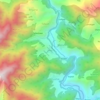
Name: Jiwai topographic map, elevation, terrain.

Location: Jiwai, Thailisain, Pauri Garhwal, Uttarakhand, India (29.92509 79.00347 29.96509 79.04347)

Average elevation: 1,640 m

Minimum elevation: 1,273 m

Maximum elevation: 2,189 m

Other topographic maps

Click on a map to view its topography, its elevation and its terrain.

Tarakund

India > Uttarakhand > Thailisain

Average elevation: 2,127 m

Gear up for your next adventure:

🧳Compression Sacks - Maximize space in your backpack by shrinking gear
🪑Ultralight Camping Stool - Compact seating for rest stops during long hikes
🔋Solar Power Bank - Keep your GPS and devices charged during long outdoor trips
🥾Lightweight Hiking Boots - Boots for comfort and mobility on long hikes
🪜Heavy Duty Carabiners - Multi-use clips for securing gear to your backpack

As an Amazon Associate, this site earns from qualifying purchases at no extra cost to you.