
Thank you for supporting this site ❤️
Make a donation
Make a donation
Gear up for your next adventure:
As an Amazon Associate, this site earns from qualifying purchases at no extra cost to you.
Cauderès topographic map
Click on the map to display elevation.
Thank you for supporting this site ❤️
Make a donation
Make a donation
Gear up for your next adventure:
As an Amazon Associate, this site earns from qualifying purchases at no extra cost to you.
About this map
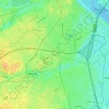
Name: Cauderès topographic map, elevation, terrain.
Average elevation: 16 m
Minimum elevation: -2 m
Maximum elevation: 34 m
Thank you for supporting this site ❤️
Make a donation
Make a donation
Gear up for your next adventure:
As an Amazon Associate, this site earns from qualifying purchases at no extra cost to you.
Other topographic maps
Click on a map to view its topography, its elevation and its terrain.
Talence
France > Nouvelle-Aquitaine > Gironde > Talence
Ce canton est organisé autour de Talence, dans l'arrondissement de Bordeaux. Son altitude varie de 9 m (Talence) à 31 m (Talence) pour une altitude moyenne de 29 m.
Average elevation: 19 m