Geolocate

Onica topographic map

Click on the map to display elevation.

About this map

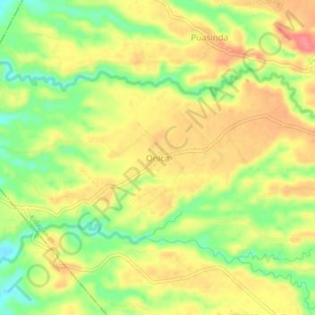
Name: Onica topographic map, elevation, terrain.

Location: Onica, Kidapawan, Cotabato, Soccsksargen, Philippines (7.01730 124.93757 7.05730 124.97757)

Average elevation: 85 m

Minimum elevation: 45 m

Maximum elevation: 118 m

Other topographic maps

Click on a map to view its topography, its elevation and its terrain.

Pulangi River

Philippines > Cotabato > Kidapawan

Average elevation: 440 m

Gear up for your next adventure:

💡Portable Camping Lamp - Rechargeable lamp for campsite lighting
🏕️Camping Hammock - Integrated protection for sleeping between trees
👟Leg Gaiters - Keep debris, mud, and snow out of your boots
Tent Footprint - Protect tent floor and increase durability
🥾Trail Hiking Shoes - Durable shoes designed for rugged trails

As an Amazon Associate, this site earns from qualifying purchases at no extra cost to you.