
Make a donation
Gear up for your next adventure:
As an Amazon Associate, this site earns from qualifying purchases at no extra cost to you.
Lonand topographic map
Click on the map to display elevation.
Make a donation
Gear up for your next adventure:
As an Amazon Associate, this site earns from qualifying purchases at no extra cost to you.
Lonand
Lonand is located at 18°02′25″N 74°11′14″E / 18.0404°N 74.1872°E / 18.0404; 74.1872. It has an average elevation of 597 metres (1961 feet). It is situated on the banks of Khemavati river at the border of Pune district and Satara district.
Make a donation
Gear up for your next adventure:
As an Amazon Associate, this site earns from qualifying purchases at no extra cost to you.
About this map
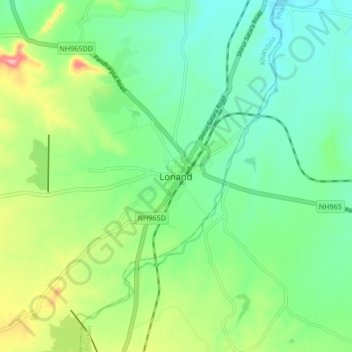
Name: Lonand topographic map, elevation, terrain.
Location: Lonand, Khandala, Satara, Maharashtra, 415521, India (17.99880 74.14693 18.07880 74.22693)
Average elevation: 599 m
Minimum elevation: 553 m
Maximum elevation: 703 m
Make a donation
Gear up for your next adventure:
As an Amazon Associate, this site earns from qualifying purchases at no extra cost to you.