
Make a donation
Gear up for your next adventure:
As an Amazon Associate, this site earns from qualifying purchases at no extra cost to you.
Am Leuchtturm topographic map
Click on the map to display elevation.
Make a donation
Gear up for your next adventure:
As an Amazon Associate, this site earns from qualifying purchases at no extra cost to you.
About this map
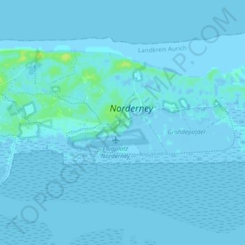
Name: Am Leuchtturm topographic map, elevation, terrain.
Average elevation: 1 m
Minimum elevation: -5 m
Maximum elevation: 12 m
Make a donation
Gear up for your next adventure:
As an Amazon Associate, this site earns from qualifying purchases at no extra cost to you.
Other topographic maps
Click on a map to view its topography, its elevation and its terrain.
Norderney
Deutschland > Niedersachsen > Landkreis Aurich > Norderney
In der Osthälfte der Insel erstreckt sich im dortigen Dünengebiet eine breite Legde, auch Schlopp genannt, die vom Strand im Norden bis zum Heller im Süden reicht. Das Gebiet rund um diesen Dünendurchbruch wird bei höheren Sturmfluten vollständig überflutet. Die gesamte Osthälfte Norderneys sowie das…
Average elevation: 0 m