
Make a donation
Gear up for your next adventure:
As an Amazon Associate, this site earns from qualifying purchases at no extra cost to you.
Abbottstown topographic map
Click on the map to display elevation.
Make a donation
Gear up for your next adventure:
As an Amazon Associate, this site earns from qualifying purchases at no extra cost to you.
About this map
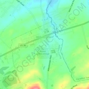
Name: Abbottstown topographic map, elevation, terrain.
Location: Abbottstown, Adams County, Pennsylvania, United States (39.87713 -76.99812 39.89126 -76.97744)
Average elevation: 167 m
Minimum elevation: 142 m
Maximum elevation: 217 m
Make a donation
Gear up for your next adventure:
As an Amazon Associate, this site earns from qualifying purchases at no extra cost to you.
Other topographic maps
Click on a map to view its topography, its elevation and its terrain.
Make a donation
Gear up for your next adventure:
As an Amazon Associate, this site earns from qualifying purchases at no extra cost to you.
Make a donation
Gear up for your next adventure:
As an Amazon Associate, this site earns from qualifying purchases at no extra cost to you.
Iron Springs
United States > Pennsylvania > Adams County > Hamiltonban Township
Average elevation: 264 m
Maria Furnace
United States > Pennsylvania > Adams County > Hamiltonban Township
Average elevation: 291 m
Make a donation
Gear up for your next adventure:
As an Amazon Associate, this site earns from qualifying purchases at no extra cost to you.
Bermudian Creek
United States > Pennsylvania > Adams County > Latimore Township
Average elevation: 166 m
Make a donation
Gear up for your next adventure:
As an Amazon Associate, this site earns from qualifying purchases at no extra cost to you.
McKnightstown
United States > Pennsylvania > Adams County > Franklin Township
Average elevation: 193 m
Make a donation
Gear up for your next adventure:
As an Amazon Associate, this site earns from qualifying purchases at no extra cost to you.
Cress Ridge
United States > Pennsylvania > Adams County > Mount Pleasant Township
Average elevation: 177 m
Make a donation
Gear up for your next adventure:
As an Amazon Associate, this site earns from qualifying purchases at no extra cost to you.
Mount Hope
United States > Pennsylvania > Adams County > Hamiltonban Township
Average elevation: 395 m
Cemetery Ridge
United States > Pennsylvania > Adams County > Cumberland Township
Average elevation: 166 m
Make a donation
Gear up for your next adventure:
As an Amazon Associate, this site earns from qualifying purchases at no extra cost to you.