
Bahati topographic map
Click on the map to display elevation.
About this map
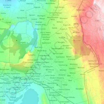
Name: Bahati topographic map, elevation, terrain.
Location: Bahati, Nakuru East, Nakuru, Rift Valley, 20100, Kenya (-0.33757 36.05473 -0.11656 36.24549)
Average elevation: 2,073 m
Minimum elevation: 1,712 m
Maximum elevation: 2,869 m
Other topographic maps
Click on a map to view its topography, its elevation and its terrain.