
Thank you for supporting this site ❤️
Make a donation
Make a donation
Gear up for your next adventure:
As an Amazon Associate, this site earns from qualifying purchases at no extra cost to you.
Rumipamba topographic map
Click on the map to display elevation.
Thank you for supporting this site ❤️
Make a donation
Make a donation
Gear up for your next adventure:
As an Amazon Associate, this site earns from qualifying purchases at no extra cost to you.
About this map
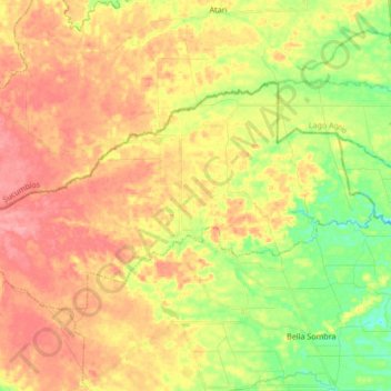
Name: Rumipamba topographic map, elevation, terrain.
Location: Rumipamba, Joya de los Sachas, Orellana, Ecuador (-0.15745 -77.06204 -0.05922 -76.89298)
Average elevation: 317 m
Minimum elevation: 272 m
Maximum elevation: 354 m
Thank you for supporting this site ❤️
Make a donation
Make a donation
Gear up for your next adventure:
As an Amazon Associate, this site earns from qualifying purchases at no extra cost to you.
Other topographic maps
Click on a map to view its topography, its elevation and its terrain.
Toyuca
Ecuador > Orellana > Joya de los Sachas > San Sebastián del Coca > Toyuca
Average elevation: 273 m