Geolocate

Pakil topographic map

Click on the map to display elevation.

About this map

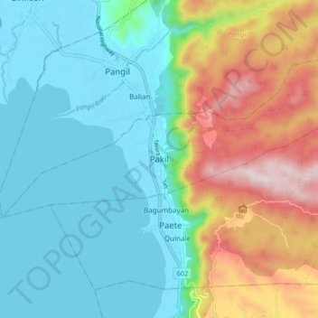
Name: Pakil topographic map, elevation, terrain.

Location: Pakil, Laguna, Calabarzon, 4017, Philippines (14.34077 121.43862 14.42077 121.51862)

Average elevation: 156 m

Minimum elevation: -7 m

Maximum elevation: 526 m

Gear up for your next adventure:

🧭Orienteering Kit - Tools for map reading and navigation in the wild
🥾Approach Boots - Comfortable boots for hiking and climbing approaches
🧥Packable Rain Jacket - Breathable waterproof layer for unpredictable weather
💡LED Headlamp - Hands-free illumination for night hiking and camping
🧥Waterproof Hiking Jacket - Protect yourself from rain and wind while hiking

As an Amazon Associate, this site earns from qualifying purchases at no extra cost to you.