Geolocate

Solivo topographic map

Click on the map to display elevation.

About this map

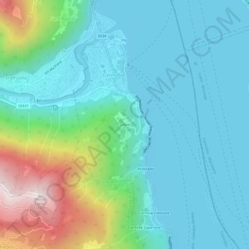
Name: Solivo topographic map, elevation, terrain.

Location: Solivo, Cannobio, Verbano-Cusio-Ossola, Piedmont, 28822, Italy (46.03382 8.68020 46.07382 8.72020)

Average elevation: 383 m

Minimum elevation: 185 m

Maximum elevation: 1,099 m

Gear up for your next adventure:

🥾Mountain Hiking Shoes - Shoes with superior grip for mountainous terrain
🧥Thermal Fleece Jacket - Versatile insulation for changing mountain temperatures
🥾Waterproof Hiking Shoes - Durable shoes for wet and rugged trails
🧭GPS Handheld Device - Reliable GPS navigation for outdoor adventures
💧Reusable Water Bottle - Durable water bottles for hydration on trails

As an Amazon Associate, this site earns from qualifying purchases at no extra cost to you.