
Make a donation
Gear up for your next adventure:
As an Amazon Associate, this site earns from qualifying purchases at no extra cost to you.
Libbenichen topographic map
Click on the map to display elevation.
Make a donation
Gear up for your next adventure:
As an Amazon Associate, this site earns from qualifying purchases at no extra cost to you.
About this map
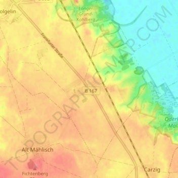
Name: Libbenichen topographic map, elevation, terrain.
Average elevation: 45 m
Minimum elevation: 7 m
Maximum elevation: 72 m
Make a donation
Gear up for your next adventure:
As an Amazon Associate, this site earns from qualifying purchases at no extra cost to you.
Other topographic maps
Click on a map to view its topography, its elevation and its terrain.
Dolgelin
Deutschland > Brandenburg > Märkisch-Oderland > Lindendorf
Dolgelin ist eines der ältesten Höhendörfer am Westrand des Oderbruches. Grabungen seit dem Jahre 2000 brachten Besiedlungsspuren aus der Bronze- und Eisenzeit ans Tageslicht.
Average elevation: 43 m