
Thank you for supporting this site ❤️
Make a donation
Make a donation
Gear up for your next adventure:
As an Amazon Associate, this site earns from qualifying purchases at no extra cost to you.
Ciales topographic map
Click on the map to display elevation.
Thank you for supporting this site ❤️
Make a donation
Make a donation
Gear up for your next adventure:
As an Amazon Associate, this site earns from qualifying purchases at no extra cost to you.
About this map
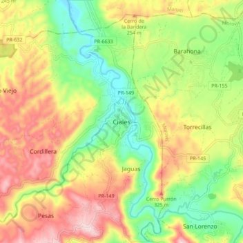
Name: Ciales topographic map, elevation, terrain.
Location: Ciales, Puerto Rico, 00638, United States (18.29660 -66.50839 18.37660 -66.42839)
Average elevation: 189 m
Minimum elevation: 17 m
Maximum elevation: 392 m
Thank you for supporting this site ❤️
Make a donation
Make a donation
Gear up for your next adventure:
As an Amazon Associate, this site earns from qualifying purchases at no extra cost to you.
Other topographic maps
Click on a map to view its topography, its elevation and its terrain.
Bosque Estatal Los Tres Picachos
United States > Puerto Rico > Ciales > Jayuya
Average elevation: 717 m