Geolocate

Teuchitlán topographic map

Click on the map to display elevation.

About this map

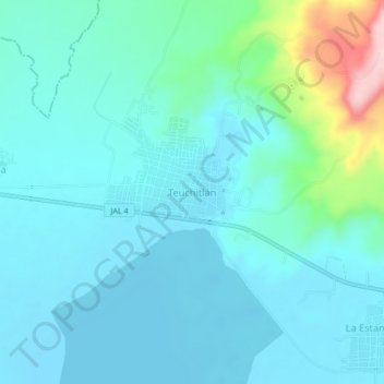
Name: Teuchitlán topographic map, elevation, terrain.

Location: Teuchitlán, Región Valles, Jalisco, 46760, Mexico (20.64372 -103.88727 20.72372 -103.80727)

Average elevation: 1,316 m

Minimum elevation: 1,255 m

Maximum elevation: 1,564 m

Gear up for your next adventure:

🥾Waterproof Hiking Boots - Boots keeping your feet dry in wet conditions
🥾Lightweight Hiking Shoes - Comfortable shoes for day hikes
🛌Down Sleeping Bag - Superior warmth-to-weight ratio for cold nights
🔨Vehicle Emergency Tool - Safety tool for remote road trips to trailheads
🗺️Topographic Maps - Detailed maps to explore trails, mountains, and wilderness areas

As an Amazon Associate, this site earns from qualifying purchases at no extra cost to you.