
Make a donation
Gear up for your next adventure:
As an Amazon Associate, this site earns from qualifying purchases at no extra cost to you.
Refuge du Lac d'Allos topographic map
Click on the map to display elevation.
Make a donation
Gear up for your next adventure:
As an Amazon Associate, this site earns from qualifying purchases at no extra cost to you.
About this map
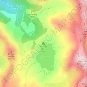
Name: Refuge du Lac d'Allos topographic map, elevation, terrain.
Average elevation: 2,340 m
Minimum elevation: 1,912 m
Maximum elevation: 2,727 m
Make a donation
Gear up for your next adventure:
As an Amazon Associate, this site earns from qualifying purchases at no extra cost to you.
Other topographic maps
Click on a map to view its topography, its elevation and its terrain.
La Foux d'Allos
France > Provence-Alpes-Côte d'Azur > Alpes-de-Haute-Provence > Allos
Average elevation: 2,094 m
Lac d'Allos
France > Provence-Alpes-Côte d'Azur > Alpes-de-Haute-Provence > Allos
Average elevation: 2,374 m
Bec de l'Aigle
France > Provence-Alpes-Côte d'Azur > Alpes-de-Haute-Provence > Allos
Average elevation: 1,989 m
La Foux
France > Provence-Alpes-Côte d'Azur > Alpes-de-Haute-Provence > Allos
Average elevation: 2,001 m
Make a donation
Gear up for your next adventure:
As an Amazon Associate, this site earns from qualifying purchases at no extra cost to you.
Le Seignus d'Allos
France > Provence-Alpes-Côte d'Azur > Alpes-de-Haute-Provence > Allos
Average elevation: 1,716 m
La Serpentine
France > Provence-Alpes-Côte d'Azur > Alpes-de-Haute-Provence > Allos
Average elevation: 2,275 m
Villard Haut
France > Provence-Alpes-Côte d'Azur > Alpes-de-Haute-Provence > Allos
Average elevation: 1,767 m
Le Seignus d'Allos
France > Provence-Alpes-Côte d'Azur > Alpes-de-Haute-Provence > Allos
Average elevation: 1,716 m
Make a donation
Gear up for your next adventure:
As an Amazon Associate, this site earns from qualifying purchases at no extra cost to you.