Geolocate

Charleston topographic map

Click on the map to display elevation.

About this map

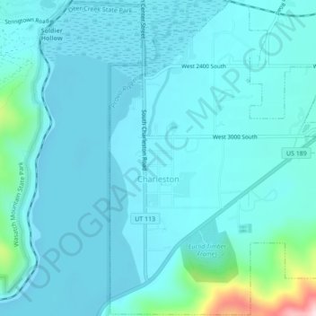
Name: Charleston topographic map, elevation, terrain.

Location: Charleston, Wasatch County, Utah, United States (40.45223 -111.47661 40.48472 -111.43353)

Average elevation: 1,685 m

Minimum elevation: 1,641 m

Maximum elevation: 2,025 m

Other topographic maps

Click on a map to view its topography, its elevation and its terrain.

Soldier Summit

United States > Utah > Wasatch County

Average elevation: 2,323 m

Heber City

United States > Utah > Wasatch County

Average elevation: 1,758 m

Gear up for your next adventure:

🛶Waterproof Dry Bags - Keep electronics and clothes dry during river crossings
🥾Hiking Leggings - Comfortable leggings for outdoor activities
🧦Thermal Socks - Warm socks for winter hiking or camping
🥾Trail Running Shoes - Lightweight and durable shoes for trail running
🥾All-Terrain Hiking Boots - Versatile boots for varied hiking conditions

As an Amazon Associate, this site earns from qualifying purchases at no extra cost to you.