
Make a donation
Gear up for your next adventure:
As an Amazon Associate, this site earns from qualifying purchases at no extra cost to you.
Las Araucarias topographic map
Click on the map to display elevation.
Make a donation
Gear up for your next adventure:
As an Amazon Associate, this site earns from qualifying purchases at no extra cost to you.
About this map
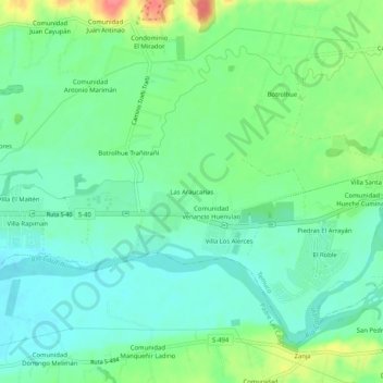
Name: Las Araucarias topographic map, elevation, terrain.
Average elevation: 82 m
Minimum elevation: 61 m
Maximum elevation: 130 m
Make a donation
Gear up for your next adventure:
As an Amazon Associate, this site earns from qualifying purchases at no extra cost to you.
Other topographic maps
Click on a map to view its topography, its elevation and its terrain.
Parque Municipal Isla Cautín
Chile > Región de la Araucanía > Provincia de Cautín > Temuco
Average elevation: 110 m
Monumento Natural Cerro Ñielol
Chile > Región de la Araucanía > Provincia de Cautín > Temuco
Average elevation: 159 m
Parque Ecológico y Natural Rucamanque
Chile > Región de la Araucanía > Provincia de Cautín > Temuco
Average elevation: 352 m
Plaza Dagoberto Godoy
Chile > Región de la Araucanía > Provincia de Cautín > Temuco
Average elevation: 116 m
Make a donation
Gear up for your next adventure:
As an Amazon Associate, this site earns from qualifying purchases at no extra cost to you.
Plaza Entrelagos
Chile > Región de la Araucanía > Provincia de Cautín > Temuco
Average elevation: 104 m
Monumento Natural Cerro Ñielol
Chile > Región de la Araucanía > Provincia de Cautín > Temuco
Average elevation: 159 m
Río Cautín
Chile > Región de la Araucanía > Provincia de Cautín > Temuco > Villa El Portal
Average elevation: 79 m