
Make a donation
Gear up for your next adventure:
As an Amazon Associate, this site earns from qualifying purchases at no extra cost to you.
Pocdol Mountains topographic map
Click on the map to display elevation.
Make a donation
Gear up for your next adventure:
As an Amazon Associate, this site earns from qualifying purchases at no extra cost to you.
Pocdol Mountains
The Pocdol Mountains form part of the boundary between the provinces of Albay and Sorsogon, in Region V, on the island of Luzon, in the Philippines. The group is located south-east of Mayon Volcano, between Albay Gulf and Sorsogon Bay, at 13°3'0"N, 123°57'30"E. The mountains have a triangular footprint of about 225 km2 (87 sq mi). There are several peaks above 1,000 m in elevation. The highest point is reported to be 1,102 m (3,615 ft) above sea level.
Make a donation
Gear up for your next adventure:
As an Amazon Associate, this site earns from qualifying purchases at no extra cost to you.
About this map
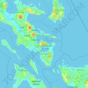
Name: Pocdol Mountains topographic map, elevation, terrain.
Average elevation: 46 m
Minimum elevation: -2 m
Maximum elevation: 2,259 m
Make a donation
Gear up for your next adventure:
As an Amazon Associate, this site earns from qualifying purchases at no extra cost to you.
Other topographic maps
Click on a map to view its topography, its elevation and its terrain.