Geolocate

Colombo topographic map

Click on the map to display elevation.

About this map

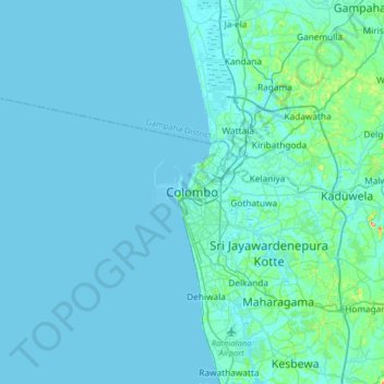
Name: Colombo topographic map, elevation, terrain.

Location: Colombo, Colombo District, Western Province, 000110, Sri Lanka (6.77875 79.69411 7.09875 80.01411)

Average elevation: 8 m

Minimum elevation: -1 m

Maximum elevation: 119 m

Other topographic maps

Click on a map to view its topography, its elevation and its terrain.

Maligawatta

Sri Lanka > Western Province > Colombo

Average elevation: 10 m

Gear up for your next adventure:

🚲Heavy Duty Bike Lock - Secure your bike at the trailhead or during stops
🏕️Camping Hammock - Integrated protection for sleeping between trees
🥾Trail Running Shoes - Lightweight and durable shoes for trail running
🧰Survival Kit - Essential gear for emergencies in the wilderness
🧦Merino Wool Socks - Moisture-wicking comfort for long-distance hiking

As an Amazon Associate, this site earns from qualifying purchases at no extra cost to you.