Geolocate

Riverhills topographic map

Click on the map to display elevation.

About this map

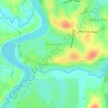
Name: Riverhills topographic map, elevation, terrain.

Location: Riverhills, Brisbane City, Queensland, Australia (-27.56797 152.89445 -27.55597 152.92271)

Average elevation: 19 m

Minimum elevation: 2 m

Maximum elevation: 50 m

Other topographic maps

Click on a map to view its topography, its elevation and its terrain.

Willmington Park

Australia > Queensland > Brisbane City

Average elevation: 37 m

Mount Gravatt

Australia > Queensland > Brisbane City

Average elevation: 70 m

Ithaca

Australia > Queensland > Brisbane City > Ithaca

Average elevation: 31 m

Gear up for your next adventure:

🥾Trekking Boots - Durable boots for long-distance trekking
🪜Heavy Duty Carabiners - Multi-use clips for securing gear to your backpack
🩹Compact First Aid Kit - Pre-packed essentials for common trail injuries
🧢Hiking Sun Hat - Wide-brimmed protection for exposed mountain ridges
🦟Insect Repellent - Keep mosquitoes and black flies away in wooded areas

As an Amazon Associate, this site earns from qualifying purchases at no extra cost to you.