
Make a donation
Gear up for your next adventure:
As an Amazon Associate, this site earns from qualifying purchases at no extra cost to you.
Ras Al Khaimah topographic map
Click on the map to display elevation.
Make a donation
Gear up for your next adventure:
As an Amazon Associate, this site earns from qualifying purchases at no extra cost to you.
About this map
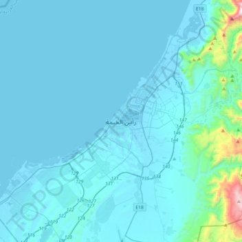
Name: Ras Al Khaimah topographic map, elevation, terrain.
Location: Ras Al Khaimah, Ras al-Khaimah, United Arab Emirates (25.61377 55.77823 25.93377 56.09823)
Average elevation: 92 m
Minimum elevation: -11 m
Maximum elevation: 1,521 m
Make a donation
Gear up for your next adventure:
As an Amazon Associate, this site earns from qualifying purchases at no extra cost to you.
Other topographic maps
Click on a map to view its topography, its elevation and its terrain.
Wadi Kub
United Arab Emirates > Ras al-Khaimah > Kub
In its upper course, the wadi is formed by two arms of similar length and flow, which originate at approximately an altitude of 542 m (1,778 ft); they border Al Jaroof to the east and west, respectively; and converge to the south of this town, defining the main channel, which initially follows the direction…
Average elevation: 324 m
Make a donation
Gear up for your next adventure:
As an Amazon Associate, this site earns from qualifying purchases at no extra cost to you.
Make a donation
Gear up for your next adventure:
As an Amazon Associate, this site earns from qualifying purchases at no extra cost to you.