Geolocate

Chambers County topographic map

Click on the map to display elevation.

About this map

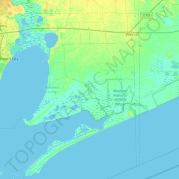
Name: Chambers County topographic map, elevation, terrain.

Location: Chambers County, Texas, United States (29.39383 -95.01820 29.89039 -94.35338)

Average elevation: 3 m

Minimum elevation: -3 m

Maximum elevation: 19 m

Gear up for your next adventure:

🛶Waterproof Dry Bags - Keep electronics and clothes dry during river crossings
🚲MTB Frame Bag - Carry tools and maps directly on your bicycle frame
🧊Portable Cooler - Keep food and drinks cold during outdoor adventures
🧰Emergency Multi-Tool - Compact multi-tool for outdoor survival
🥾Trail Hiking Socks - Comfortable socks to prevent blisters and fatigue

As an Amazon Associate, this site earns from qualifying purchases at no extra cost to you.