Geolocate

Yale topographic map

Click on the map to display elevation.

About this map

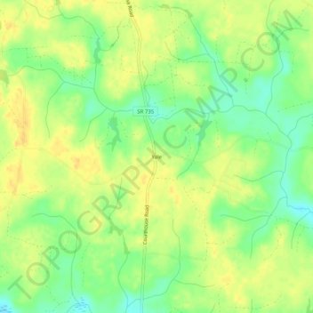
Name: Yale topographic map, elevation, terrain.

Location: Yale, Sussex County, Virginia, 23897, United States (36.82571 -77.30747 36.86571 -77.26747)

Average elevation: 31 m

Minimum elevation: 15 m

Maximum elevation: 42 m

Other topographic maps

Click on a map to view its topography, its elevation and its terrain.

Jarratt

United States > Virginia > Sussex County

Average elevation: 47 m

Waverly

United States > Virginia > Sussex County

Average elevation: 33 m

Gear up for your next adventure:

🥾Hiking Shoes - Durable and comfortable shoes for trail hiking
🧊Insulated Water Bottle - Keeps drinks cold in summer and prevents freezing in winter
🧦Thermal Socks - Warm socks for winter hiking or camping
💧Reusable Water Bottle - Durable water bottles for hydration on trails
🥾Durable Hiking Shoes - Long-lasting shoes for frequent hiking

As an Amazon Associate, this site earns from qualifying purchases at no extra cost to you.