
Make a donation
Gear up for your next adventure:
As an Amazon Associate, this site earns from qualifying purchases at no extra cost to you.
Lac Miroir topographic map
Click on the map to display elevation.
Make a donation
Gear up for your next adventure:
As an Amazon Associate, this site earns from qualifying purchases at no extra cost to you.
About this map
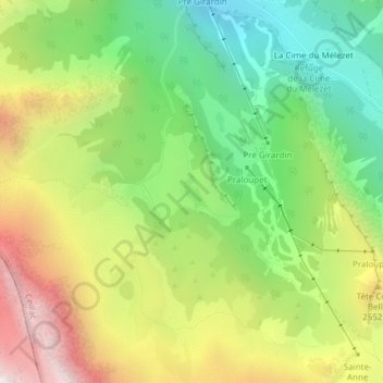
Name: Lac Miroir topographic map, elevation, terrain.
Average elevation: 2,289 m
Minimum elevation: 1,702 m
Maximum elevation: 3,081 m
Make a donation
Gear up for your next adventure:
As an Amazon Associate, this site earns from qualifying purchases at no extra cost to you.
Other topographic maps
Click on a map to view its topography, its elevation and its terrain.
La Rua des Reynauds
France > Provence-Alpes-Côte d'Azur > Hautes-Alpes > Ceillac
Average elevation: 2,052 m
Le Pied du Mélezet
France > Provence-Alpes-Côte d'Azur > Hautes-Alpes > Ceillac
Average elevation: 2,097 m
Make a donation
Gear up for your next adventure:
As an Amazon Associate, this site earns from qualifying purchases at no extra cost to you.
La Cime du Mélezet
France > Provence-Alpes-Côte d'Azur > Hautes-Alpes > Ceillac
Average elevation: 2,162 m